

Photo Record
Images
Metadata
Catalog Number |
2019.00798 |
Object Name |
Print, Photographic |
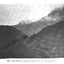
Description |
The Hengduan Mountains cover much of western present-day Sichuan province as well as the northwestern portions of Yunnan, the easternmost section of the Tibet Autonomous Region, and touching upon parts of southern Qinghai. Additionally, some parts of eastern Kachin State in neighbouring Myanmar are considered part of the Hengduan group. The Hengduan Mountains are approximately 900 kilometres (560 mi) long, stretching from 33°N to 25°N. Depending on extent of the definition, the Hengduan Mountains are also approximately 400 kilometres (250 mi) wide under the narrowest definition, ranging from 98°E to 102°E. The area covered by these ranges roughly corresponds with the historical region known as Kham. The Hengduan Mountains subalpine conifer forests is a palaearctic ecoregion in the Temperate coniferous forests biome that covers portions of the mountains. |
Date |
1911 |
Photographer |
Dr. William Edgar Geil |
Title |
The Road from Chowtung to Yunnan (The Hengduan Mountain System) |
Copyright |
Doylestown Historical Society |
Collection |
WM. Edgar Geil Collection |
Cataloged by |
Tony Palazzolo |
Orig/copy |
Copy |